The Cotswold Way starts from the historic city of Bath and follows Cotswold scenes past a noted Civil War site and a stately home.
| Distance: | 14.5 Miles | |
| Est. Time: | 6 hrs 50 mins | |
| Difficulty: | Moderate | |
| OS map: | Explorer sheet 155 | |
| Total Ascent: | 1726 ft | |
| Total Descent: | 1184 ft | |
Register to create & share your own walks
Highlights
Bath city sights
- Views from the Cotswold ridge
- English Civil War battlefield
- Dyrham Park
The Cotswolds attract International visitors from countries with higher peaks, faster, broader rivers and taller trees, but this modest range of hills has its own superlative classic beauty. The city of Bath is an appropriate start point with its classic Regency buildings and sweeping views. But varying views delight the eye again and again as the walk winds up through the Cotswold countryside, past ancient battlefields, sleepy villages and stately mansions. [Much of the Cotswold Way route is signposted with an acorn symbol]
The Route 
Cross Queen Street and continue ahead into Queen Square. Turn right into the square and walk (carefully) round two sides of this busy thoroughfare to the opposite corner of the square. Turn right and walk up through the gates and into Royal Victoria Park (GR 747651). [Public toilets can be found near the park entrance.] Walk through the park up Royal Avenue.
Pass through the gates to come out of the park, cross Marlborough Lane and walk directly ahead [signposted Bird Aviary, Play Area, Lake, Toilets, Botanical Gardens and enter another park. Pass a prominent monument, erected in honour of Queen Victoria (GR 724653) and notice the Aviary next to a cottage across the lawn on the right. Continue past the monument and, at the fork, take turning sharp right and follow the park road as it sweeps round to the left to meet a road. Cross the road to enter another area of parkland designated as the City of Bath Approach Golf Course (GR 742656). You are now in the Lansdown suburb of Bath. Follow the asphalt path uphill between the greens. As you climb you are rewarded with great views back across the centre of Bath.
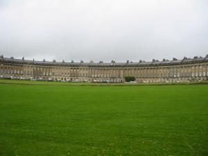
[The imposing arc of Royal Crescent can be seen on the right, overlooking the park.]
Go through a kissing gate (GR 733665) and continue a short way along the path and then down a short stretch of road and onto another section of footpath (signposted Cotswold Way). That leads to a quiet road that passes some houses and a churchyard. At the junction turn right (GR731663) [the signs are hidden here] and go through the churchyard in front of All Saints church. [NB If you need supplies you can divert into Weston village by turning left at the junction and go down some steps.] Cross the road in front of the Kings Head public house, then cross a much busier road in front of the Crown & Anchor and walk up the one-way street beside that pub (Pen Hill Road). At the top of Pen Hill Road turn right and follow the main road for about 150 yards, then turn right through a kissing gate at the end of a row of concrete houses (GR 727663).
At last you are in the country!
Walk diagonally across a playing field towards Penn Hill aiming for a visible gap in the trees on the other side of the field. Go through a kissing gate and climb the hill to another kissing gate. Follow the path between hedges up to a stile at the top of Penn Hill. From here you can see the Cotswold Way for some distance ahead along the ridge. Cross the top of a field and go onto a road (GR 719667). Continue ahead following the road, which soon becomes a track. 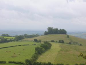
Continue on the same route and, again, the Cotswold Way can be seen for some distance ahead. Across to the left from this section you can see Bristol and (if the weather is clear) the Welsh hills. Go through a gate and turn left and promptly go through another gate and turn right, then go through a kissing gate into an area known as Shiners Wood. Access to Shiners Wood is allowed only by the Cotswold Way (walkers must keep to the path).
Go through a kissing gate and follow the path as it veers left and then right through another kissing gate onto Prospect Stile. This is a 230 metre (764 ft) high viewpoint (the highest point of today's walk) (GR 713683). After going through that kissing gate turn left and walk along the hill at the corner of Bath Racecourse grounds. Continue to another kissing gate then go through and walk along the edge of a field.
Follow the path round the field edge and then turn left to go through a wide gap in a wall. Cross the hill to a gate then go steeply downhill leaving the high point of the walk. After about 100 yards turn right following the Cotswold Way acorn sign. This is marked on the map as the site of an old fort. Go through a gate and continue ahead and part way across the field turn right onto a wider track leading up the hill (GR 710692 shown on the map as the site of a Roman Camp). Go through a gate and continue ahead alongside a golf course (beside Pipley Wood).
Continue to follow the path through the golf course and past an old barn and at the edge of the golf course turn left onto a bridleway (GR 719695). Cross a small road and continue on the bridleway. Next to a field entrance veer slightly left and begin a short descent then turn right into a field following the Cotswold Way sign (this is where you finally leave the golf course behind you). Walk along a few yards and pass through another gate.
The path is poorly defined at this point, but keep along the edge of the field, keeping the wall and ridge on your left and continue to a kissing gate marked by an orange flag-shaped sign on a blue pole (GR 713702 Hanging Hill). This is the first of a series of memorial markers you will pass showing the site of the Battle of Lansdown (1643) which was a significant Civil War engagement.
Turn right at Hanging Hill, next to the Battle memorial and walk towards a communications mast and another orange/blue battle marker showing the site of the Roundhead encampment on the night before the battle. Go through a gate into Beech Wood, then pass another orange/blue sign, where you turn right (GR 717703)
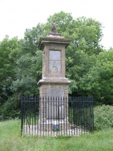
Next to yet another Battle of Lansdown flag turn left and go through a kissing gate. Here the path again becomes ill-defined and overgrown so that, following rain or heavy dew, you can expect to get wet from the tall grass. Go through a gate and turn left onto a road at GR721703. Walk along to the next Battle of Lansdown flag and turn left to go through the hedge and carefully cross the major road called Freezing Lane. On the other side of the road pass another Battle of Lansdown flag and further information about the battle (GR721702).
After going through the kissing gate walk diagonally right across a field in the direction of a lake that you can see in the distance. Continue down the hill past a seat into the valley and across to another kissing gate. Follow the path down to the bottom of the valley. Come to a metalled farm track and turn left over a cattle grid at a point that some maps mark as a ford (it is now bridged) and follow the farm track uphill. Go over another cattle grid and turn right just after some farm buildings at Lower Hamswell (GR 734710). Cross the field towards some large trees and go through a gateway. Continue ahead keeping more-or-less to the centre of the field. Go through a gate and straight across the next field. In the corner of the field, go through a kissing gate to join a trackway (GR 737716). Go down through the woods to join Greenway Lane.
Walk up the concrete track through the gate of Vale Court Farm and turn left onto a road opposite Hill Farm (GR 738717). As you climb the hill you will see a seat ahead and then pass a garden centre serving tea, coffee and cold drinks. Continue up the road and follow it round to the right to the top of the hill. Cross the busy A46 road (GR 745725) near its junction with the A420. Having cross the A46 continue on the same road into the village of Cold Ashton. Continue ahead past the telephone box, through the village and past the end of Swale Lane and past an imposing old stone house in a walled garden and at the end of a high wall turn left, following a signpost to the church (GR 751727). Go through a kissing gate and through the churchyard to another kissing gate. Continue along the path next to a wall.
Cross the A420 road opposite the White Hart public house (GR 750730) and turn left to walk alongside the road. Walk past some cottages and a few yards further along turn right to walk across a field on a patch signposted to Pennsylvania and Dyrham (GR 749729).
Cross a stone stile and continue through the field towards the tiny village of Pennsylvania. Cross the A46 again (GR 744733) and walk up the narrow road past the house behind the filling station. After the houses the road becomes a grassy path between hedgerows and then goes along the edge of a field. Go through a kissing gate (GR 741738) next to Gorse Lane and follow the path parallel to the road (behind the hedge) to a kissing gate. Cross the road (carefully traffic comes fast here) and go through another kissing gate and proceed directly across the next field. Go into Dyrham Wood, where the path veers slightly to the right. Go through a kissing gate and out into a field (GR 737742).
The path is little more than a discoloration in the grass, but follow it across the field to a kissing gate hidden in the hedge on the bottom edge. Walk down and through woods, cross a footbridge over a stream and then go through another kissing gate and up another grassy field to a gateway. The route seems to veer to the right (GR 738747) but the Cotswold way actually continues ahead as the smaller of the visible paths. Cross a field, go past the end of a line of trees, past a large pond, through a kissing gate and across another small field to a further kissing gate. The path continues under a canopy of tree to another kissing gate and then along the bottom edge of a field.
Go through a kissing gate beside a tree that has a seat built round the base and turn left onto a road a Dyrham. Follow the road down through the village then turn right at the triangular green (GR 740756). Go past the back entrance to Dyrham Park and continue along the road beside the high wall and on uphill past Dyrham House and some cottages. Turn off the road onto a bridle path (GR 739759) signposted to Hinton Hill, Tormarton and West Littleton. Go through a qate and across the top of a field to another gate. Walk parallel to the Dyrham Park boundary fence across the top of the next field to a double gate.
Go through another gate and go up a small hill into a field, still following the Dyrham Park boundary. At the end of the field turn left onto Field Lane (GR 747765). Come to a road junction and pick up the footpath slightly to the left on the other side of the road (GR 747769). Continue ahead below power lines, keeping to the left hand edge of a field (you can probably hear the M4 traffic now). Continue along the field edge, veering to the right towards a communication mast among trees. Go through a gap into another field and turn right towards the mast. Follow the path along the right hand side of the field and then turn right through woods to go into a public car and lorry park (GR 756778).
Safety 
The most dangerous parts of this route are the busy road crossings (e.g. A46 and A420). Some parts of the route are fairly steep, but the route underfoot is forgiving, well marked and easy to follow. The overall distance of this first section is 15.6 miles.
Notes 
Bath, an ancient city built around a hot spring and alongside the River Avon, has been important since Roman times, but the city grew considerably in the Regency period and under George IV. That period contributed most of the city's popular sights, including the Royal Crescent, which can be seen from this walk as you pass through Victoria Park.
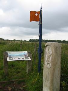
This walk follows the line of the parliamentary entrenchments and passes a memorial placed at the spot where Sir Bevil Granville was mortally wounded. The path even crosses a wall that formed part of the battle line at the time of the engagement.
Dyrham Park - This grand house and its 274 acres of parkland is owned and managed by The National Trust. It dates back to the 17th century and parts of it were designed by the same architect that designed the famous Chatsworth House (Derbyshire). It contains some fine period furniture and artworks and the park is home to a large herd of deer that you may glimpse as you walk along the surrounding wall and fences. The house has been used as a location for films such as 'The Remains of the Day' and 'Merchant Ivory'.
Hanging Hill is a typical name for a prominent high point at the boundary between two or more communities which was once used for executions.

Shiners Wood is a 34 acre area of native woodland managed by the Forestry Commission with a number of traditional species such as oak, ash, wild cherry, field maple, rowan, silver birch, hazel.
Victoria Park, Bath has a prominent monument, erected in honour of Queen Victoria, and as you pass that monument you can also see an Aviary next to a cottage across the lawn on the right (it houses popular cage birds such as budgerigars, parakeets and zebra finches).