A varied walk uphill, down dale and through villages - but never far from the beautiful River Wye.
| Distance: | 13.2 Miles | |
| Est. Time: | 5 hrs 50 mins | |
| Difficulty: | Easy | |
| OS map: | Explorer sheet 189 | |
| Total Ascent: | 978 ft | |
| Total Descent: | 1043 ft | |
Register to create & share your own walks
Highlights
 Merback Hill
- Bredwadine Bridge
- Cider orchards
- Riverside walks
This section includes more riverside walking than Section 1 - plus some fine viewpoints.
The Route 
(NB this route picks up from Section 1. If you stayed overnight at Middlewood or Clock Mills resume the route from an appropriate point).
Pass the Middlewood turning and continue up the hill for a few paces to where a green lane leads off to the right (signposted to Merbach). Follow the green lane through to a road and continue straight ahead. After about 20 yards turn left onto a bridleway, which shortly turns right to ascend Merbach Hill.Go through a gate and follow the bridle path right (through woodland) and continue following the blue arrows (ignore the yellow ones) as the path winds up the hill. The path does not go to the summit of Merbach Hill (1043 feet/318 metres) but this can be reached by a short diversion to the right (which is worth the trouble).
Back on the path, as you go down the hill you will come to a T-junction. Turn right and walk about 25 yards, then turn left over a stile to follow a permissive route along the right hand edge of a field. A gate then takes you back onto a public footpath to another gateway leading to the edge of Westonhill Woods. Pass through another gate and walk alongside the woods towards a gate beside a rusty barn. Go through that gate and head across a small field (veer slightly right) to a further gate. There is a good view of the River Wye at this point. Follow the path down the hill and, just before Woola Farm, turn right onto a footpath, through a gate into the woods.
The footpath comes back out onto the farm track; continue ahead past a stand of conifer woods, over a cattle grid and on past some farm buildings (Benfield Farm) where the track becomes a metalled road. At a left hand bend in the road, turn right and go through a gate onto a bridle path. The bridleway comes up to a grassy field with no sign of a path and a complete absence of signposts! Head diagonally across the field to a metal gate in the right hand corner.
Turn left onto a road and follow it down, past a junction (signposted Fine Street and Arthur's Stone) and then down a 1 in 4 hill (25%) leading to Bredwardine. Pass the Red Lion pub/hotel and go straight across the crossroads. At the sign for Bredwardine Church turn right, walk to the left of the church, cross a stile and head down towards the river.
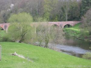
Cross a narrow footbridge over a small stream and continue on to cross a narrow road bridge over the River Wye. Follow the road up to a crossroads where you turn right and walk down, eventually coming to a junction with the driveway for Old Court. Turn left and continue on the road. Ignore the prominently signposted bridleway part-way up the hill, but continue up to a lay-by, where a bridleway branches off to the right.
Follow the bridleway up the hill, between mature trees and look right to catch more views of the River Wye. At the top of the ridge look out for a blue sign taking the Wye Valley Walk left and follow the footpath a short way down to a gate, where you turn right following a field edge. Go through a gate onto a track and carry on in the same direction and through another gateway until you reach a gate on the right.
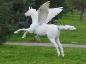
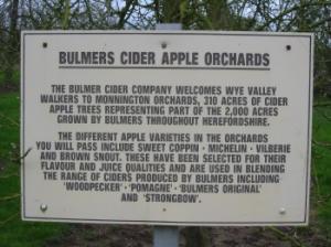
Pass through to join the broad, grassy avenue of Monnington Walk. Go through a gate and join a drive leading alongside cider orchards towards the impressive buildings of Court Farm.  Where the drive changes surface (close to a statue of a winged horse) veer left and cross a cattle grid next to Monnington House. Immediately after the house, turn right onto a bridleway beside another cider orchard. Go through a gate to walk behind Court Farm House, then through a lych gate and through part of a churchyard. At the other side of the churchyard turn left, go past a pond then veer right to walk along the edge of a large Bulmers Cider Orchard.
The path soon brings you close alongside the River Wye. Keep following the edge of the orchards, parallel with the river, until the river turns away and a blue arrow points you left across the orchard. Cross a wooden footbridge over a brook and walk along the left hand edge of a field. Follow the field edge round for quite a distance until you come to an opening. Walk through into another field to pass between young trees (on the left) and a rough stand of willow (on the right).
The path turns into a rough track that eventually comes out to a road in the village of Byford. Turn left and walk up through the village to the main road (A438) where you turn right. Walk about 100 yards then turn left (opposite a telephone box) and go through a gateway (past a lodge) and into the Garnons House estate. Follow the roadway up and then turn right, following a yellow arrow sign. Walk past Home Farm and some other houses and the road shortly begins to follow the route of an old Roman road. At a crossroads continue straight ahead through he village of Bishopstone. Keep straight on, ignoring all side turnings, and on through Kenchester (where the road veers right). When the road bends right again beside a pool surrounded by trees, cross to a gate and go through onto a footpath.
Follow the footpath along the left edge of a field to Sugwas Pool Cottage, where you find a gate to a path leading behind the cottage.
Go through a gap and on to a track, which bends left and then right and becomes a residential road leading up to the A438 Hereford road. There is some accommodation nearby - or go to the outskirts of Hereford.
Safety 
The Wye Valley Walk is not a mountain route, but it includes some stiff climbs and several sections that can be very muddy. The week-long walk should not be attempted without proper walking boots and wet weather gear
Notes 
 Bredwardine - Look out for a fine arched bridge, the Red Lion pub, and the church (one of the past vicars was Kilvert, the writer) at this riverside village. The area is good for fishing (take a look at the preserved specimen salon in the Red Lion).
Bulmers Cider - The walk passes through and beside several of Bulmers' cider orchards and they cover considerable acreage. Look out for lots of mistletoe on some of the orchard trees.
Merbach Hill - At 1043 feet (318 metres) this hill provides and impressive vantage point to view the Wye Valley and surrounding areas. A stiff climb through woodland eventually brings you out to an open path with Wye views. The summit is only a few yards off the Wye Valley Walk route and is worth the diversion. Sit down awhile and enjoy the view.
Monnington - Close to the large Bulmers orchard you will find Monnington church (St Mary's) at which is is said that the welsh leader, Owain Glyndwr, was buried. Notice Court Farm (just before the church) and its striking selection of statues at the end of the long straight track known as Monnington Walk.