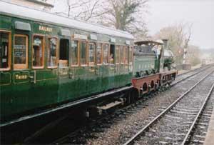
Woodland, reservoir and viewpoints, plus the Bluebell Railway and other memories of the age of steam.
| Distance: | 4.9 Miles | |
| Est. Time: | 2 hrs 00 mins | |
| Difficulty: | Very easy | |
| OS map: | Explorer sheet 135 | |
| Total Ascent: | 0 ft | |
| Total Descent: | 0 ft | |
Register to create & share your own walks
Highlights
- Bluebell Railway
- Historic railway scenes
- Sussex countryside
This circular walk begins and ends at the bottom of Station Road, Sharpthorne, at the site of the long-demolished West Hoathly station (OS ref. 371328). The grass-covered remains of the station platforms are clearly seen, and from the railway crossing there is a good view of the northern end of Sharpthorne tunnel.
The Route 
 With the Bluebell Railway line on your right, go forward into the concrete farm road (signed West Sussex Border Path). Shortly after the old house and the pond on the left, follow the road round to the right and go under the railway bridge. Cross the stile by the locked gate, continue through the farm, and follow the road downhill until it turns left. At this point, continue forward on a cross-field path between fences (signposted Sussex Border Path).
On reaching the wood on the far side of the field, cross the stile and continue down a clear track. Cross the footbridge and bear left on a rising gravel track, ignoring paths to left and right. When the track reaches the field on the brow, continue forward on the narrow, sunken footpath between the lines of trees, until reaching the stile at the road (opposite cottages). Cross the stile and turn left on the road (OS ref: 379340). Walk along the road for about five hundred metres (take care: narrow lane with limited visibility). An option is not to go out onto the road, but to walk parallel with the road, inside the fields; this is not a right of way, but it is safer.
After passing Legsheath Lane on your right, you cross the end of Weir Wood reservoir.
Immediately after the locked Southern Water gate on the left, turn sharp left up a narrow steep path and follow the fence line to a stile. Go over the stile, and go forward, passing the pylon immediately on your left and walk up the steep field, aiming for a stile with high rocks beyond. Cross the stile and bear right on rising ground. Walk along the base of the line of rocks, keeping them on your left. (Good views of Weir Wood Reservoir). After the last rock, the path joins a broad, clearly defined path; turn left onto it. This path passes along the top of the line of rocks. (Safety note: if you have children or a dog with you, keep them away from the sheer drops.)
In about four hundred metres, cross the stile or go through the gate into the field. Bear left on a descending cross-field path (aim for the pylon). Continue down this field to a gap in the line of trees and then bear right to a footbridge. Having crossed the footbridge, turn left and aim for a gap in the wood on far side of field, marked by a finger post.
On reaching the wood, continue forward on clear path as far as the stile. Climb steeply up the Bluebell Railway embankment. Before crossing the line, stop, look and listen, to make sure the line is clear. (Kingscote station is up the line to your right, Sharpthorne tunnel and Horsted Keynes are down the line to your left).
Having crossed the line, descend steeply to the stile, cross it and follow the path to the road. Turn left onto the road. Where the road rises to the entrance to Birch Farm Nursery, turn right through the metal five-bar gate into the field, crossing to the stile in the far right corner. Cross the stile into the woods. In one hundred and fifty metres, turn right onto a crossing grassy track. (In dry conditions, it is possible to continue on the line of the footpath rather than turn right onto this grassy track. The footpath then reaches the rough forest road as below.) In one hundred and twenty five metres, turn left where the grassy track meets a rough surfaced forest road. (This is a permissive bridle path through Forestry Enterprise woods.) Stay on this rough road for one mile, ignoring all turnings to left and right. At the end of the road, go through gap at the side of the double gates and come to the end of the walk.
This circular route was walked and checked in May 2004
If you found any ambiguity or inaccuracy in this route description, please let us know at mandrhoran@supanet.com
Safety 
This is not a difficult walk but care is needed when crossing roads or railway lines. One section runs alongside a steep emnankment.
Notes 
BUS ROUTES
Check services and times with Metrobus at 01293 449191 or www.metrobus.co.uk
No.82 Crawley Down/Crawley/Three Bridges/Haywards Heath.
No.84 East Grinstead/Sharpthorne/Crawley Down/Three Bridges Crawley (no Sunday service).
Other buses to and from Crawley Down include the No.624 Horley and East Grinstead, No.684 East Grinstead/Crawley Down/Crawley, 291 East Grinstead and Tunbridge Wells, and the 391, 692, and 693 Crawley buses.
There is limited public transport at Kingscote - the 473 goes to and from East Grinstead.