An easy circular route through pretty Exmoor scenery via the longest clapper bridge in the country. (NB: THE STONES OF TARR STEPS WERE SWEPT AWAY IN THE 2012 FLOODS AND WILL REMAIN INACCESSIBLE UNTIL THE BRIDGE IS REBUILT)
| Distance: | 6.9 Miles | |
| Est. Time: | 3 hrs 20 mins | |
| Difficulty: | Easy | |
| OS map: | Explorer sheet OL9 | |
| Total Ascent: | 1063 ft | |
| Total Descent: | 1063 ft | |
Register to create & share your own walks
Highlights
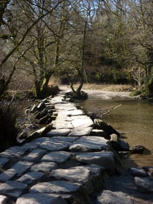
 Tarr Steps - the longest clapper bridge in the country
- River Barle - one of Exmoor's gems
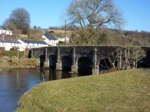
- Landacre Bridge - spanning the River Barle in 6 stone arches
- Beautiful Exmoor scenery
The Route 
Start at the Exmoor National Parks car park for Tarr Steps (GR872324). From the car park, walk down the permissive path that begins beside the notice near the exit. The path runs parallel to the road and comes out to the road almost opposite Tarr Farm. Continue down to Tarr Steps (GR 868321) and, after enjoying the view and creating your perfect photograph, cross the river Barle by means of this unique clapper bridge.
Cross the bridge, walk a few paces along the road and then turn right onto the public bridleway signposted for Withypool Hill and Hawkridge. Veer right, avoiding the gateway (marked “private”) and follow the path steeply uphill. [The route to Withypool is signposted by means of blue painted marks on gates, fences and walls - sometimes arrows, sometimes just spots of paint.] Go through a gate, after which the path bends sharp right. At the top corner of the field (GR 865322) don’t go through the gateway, but turn sharp left and follow the path across the top of the field to another gateway. Go through that gate into the land of Parsonage Farm (a notice advertises refreshments and B&B available at the farm). You are now nearing the top of this hill.
Walk along the left hand edge of the field and go through another gateway (GR859321). Just before the next gateway, which is the entrance to Parsonage Farm, follow the path to the right and continue along the edge of the field. Go through a gate and continue straight ahead. Go through a gate to another field and continue straight ahead to cross to the opposite corner of the field. Go over a wooden stile and walk ahead, following the sign to Withypool (2 miles). Don’t be misled by the parallel, sunken path to the right; it goes the same way, but is overgrown and hemmed in by low trees; the path to follow is the higher one running along the bank.
 Go through a gate (a sign says “Westwater Farm 0.1 mile”) and cross the field alongside a line of large trees. At Westwater Farm, go through a gate and turn right on a road (Worth Lane) to cross a bridge beside the farm (GR848330). You are now following the Two Moors Way and the route follows this road all the way to Withypool.
[On the way, the road crosses a cattle grid, here a bridle path leads off to the left towards Withypool Hill, where there is a stone circle and tumulus – a possible extension loop for those wanting a longer walk.]
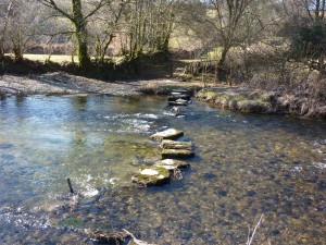
[As you come down the hill towards Withypool an alternative route to Tarr Steps is signposted right via a bridle path and ford. The map shows “stepping stones”, but they are not complete and you will get at least your feet wet if you go this way]
Walk down the hill right into Withypool, cross Landacre bridge over the river Barle (GR844354) and then turn right to walk right through the village, past a shop, tea room and public conveniences. The route back to Tarr Steps is well signposted. Follow the road through the village, past a pub and cross a small stream at Mill Bridge. Continue up a steep hill (20%, or 1 in 5) and leave the road at a stile on the right, half-way up the hill (GR850356). Walk about 20 yards, cross another stile and continue through woodland. Cross a stream below a small waterfall and walk along towards a gate. just before the gate, turn right and follow the path along the edge of the hill with the river below to your right. For a short way, the path consists of a boardwalk, then it crosses another stream and goes through a gate to join a Permitted Path alongside the river. Cross a plank bridge and continue along the river bank.
Notice an incomplete row of stepping stones crossing the river (GR851350); this ford is at the other end of the signposted “short-cut” from the Two Moors Way road leading down into Withypool. It is possible to cross when the river level is normal, but not without getting your feet wet (if not your legs and more!).
 The path splits into two, of which either is OK. However, if conditions are not too muddy, the right hand path stays closer to the river bank and it the prettier route. After about 200 yards, both paths come together again at a gate GR831344). Go through the gate and continue parallel with the river, but now alongside a fence. The path goes through another gate and back into woodland, still following the river, although gradually rising higher above it. Go through a gate and cross a field, following the path as it takes a short-cut away from the river bank, as the river meanders around in a wide loop. At the next gate, the path resumes friendly relationships with the river and then the path splits randomly... but keep as close to the river as conditions allow (it can be very muddy here).
Another path joins from the left, but the route back to Tarr Steps continues ahead to cross a small wooden footbridge then go through a narrow gate. Cross two small streams, one unbridged and the other offering the rickety remains of a wooden footbridge [if you are lucky, this be repaired by the time you use the route]. Cross two more streams/rivulets as you come to a more open section. Then cross another unbridged stream and re-enter woodland as you cross a stile, followed by a wooden bridge.
Ford a couple more brooks and carry on in the same direction. Go past a wood-and-steel bridge (GR860328) which offers an alternative permitted path back to Tarr Steps along the opposite river bank. But the main path continues past the bridge, through a gate, over a wooden bridge and into Knaplock Wood. The route splits into a bridleway to the left (higher level) or a footpath down to the right (river bank); the bridleway does not return to Tarr Steps, but joins the road just above Tarr Farm (with another option of a path leading to the tearoom gardens). The lower footpath returns to Tarr Steps. From the bridge (or the tearooms) walk back up the hill to return to the car park
Safety 
With no significant height gains and no major roads to traverse, this route presents few safety challenges. But it crosses a river on a moor known to produce sudden floods, so don't take chances. Parts of the route can easily become muddy and good footwear is advisable.
Notes 
River Barle
This pretty river rises in an area of Exmoor known as The Chains (highest point Chains Barrow at 1,599 feet or 487 m) and flows down to join the River Exe at Exebridge.
Tarr Steps
This ancient clapper bridge crosses the Rover Barle in 17 spans totalling over 50 metres long (180feet) and it is probably the longest of its kind. Clapper bridges, of which there are several in the area, are distinctive structures built of stone slabs laid together without mortar. This one was probably built in mediaeval times (anywhere between the years 1100 and 1500) although some historians believe it is older.
Withypool
This small, pleasantly situated village is at approximately the half-way point on this walk and is a key bridging point over the River Barle. It has a car park, a pleasant grassy area beside the six-arched Landacre Bridge, and provides opportunities for supplies and refreshments (a shop, public conveniences, a tea-room and a pub that serves food and offers B&B).